Missing Dog Update: My dog Leah was seen near the Moose Casino in Mountlake Terrace--66th Ave W and 220th St SW. If anyone is in the area and sees here, let us know right away! (see link on right)
We are now going into a very different, and much more active, weather period--and it starts today!
A strong front is now approaching the Washington coast and it will result in VERY strong winds in the Strait of Juan de Fuca, possible damage (power outages, localized flooding on Whidbey Island), blustery conditions and rain elsewhere, and snow in the mountains. And I don't even want to tell you what the models are suggesting for next weekend.
Perhaps the most profound weather phenomenon today is one I am actively researching: a powerful westerly wind surge in the Strait of Juan de Fuca.
Under the proper conditions, strong westerly winds can surge eastward into the Strait, reaching speeds of 50- 80 mph. Sometimes called Westerly Strait Surges, one will occur today. A particular strong surge destroyed Ivar's Mukilteo Landing restaurant in 2003 (now rebuilt and my favorite restaurant) and another heavily damaged the Washington Ferry Elwha when it was under repair in Everett Harbor (December 1990). Some pics of the damaged and rebuilt Ivars, which now has a weather theme:
The situation associated with westerly straight surges will occur today: a broad ridge over the eastern Pacific, northwesterly uper-level flow over western Washington, and a sharp trough pushing into our region in this flow. Here is the situation predicted for this afternoon at 500 hPa--about 18,000 ft above the surface:
You can see the strong trough embedded in intense northwesterly flow (remember the flow is parallel to the height lines and close spacing means strong winds). As the trough passes through the winds aloft are aligned with the Strait....here are the height lines at 850 hPa (around 5000 ft) to illustrate:
You see how the height lines, and thus winds, are parallel to the Strait? And the strong gradient of the height lines (thus strong winds) are clear. At the surface, the front is associated with a trough of low pressure, so as it passes eastward an intense low level pressure difference (high to the west, low to the east) develops and air likes to accelerate from high to low pressure. Here is the sea level pressure forecast for this afternoon at 4 PM. Pressure is increasing rapidly up the Strait.
Strong northwesterly winds aloft and big pressure difference down the Strait both support strong westerly winds that can slam in the eastern Strait, with Whidbey Island, Everett, and vicinity taking the brunt of it. Winds can gust to 40-80 mph. This one is not completely ideal....so I would not look beyond 60 mph today. Here are the WRF model forecasts for this afternoon at 1 PM. Strong sustained winds of 35 knots have pushed into the Strait (and gusts would be stronger).
Three hours later, strong winds have reached Whidbey Island and the eastern Strait (Port Townsend and the NE tip of the Olympic Peninsula should get a taste of this as well).
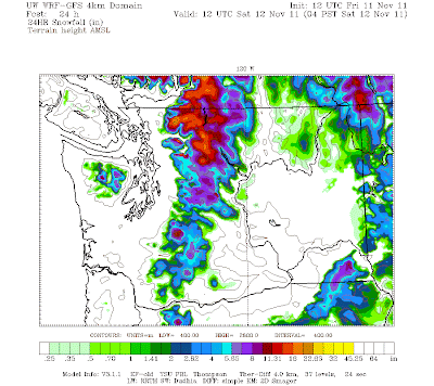
The freezing and snow levels should drop as cold air behind the front floods the region. With the flow directed up the mountains, enhanced precipitation in the form of snow should hit the mountains at and above pass level (more at the higher passes of course). Here is the forecast 24-h snowfall ending 4 AM on Saturday. The model suggests a foot in the northern Cascades dropping to an inch perhaps at Snoqualmie.
Then another system comes in on Saturday with more rain in the lowlands and snow in the Cascades. Here is the snowfall for the next 24-h--even more!
Good news for skiers!...we are going to start building the base they long for. Skiing by Thanksgiving may well be in sight.
And now let me tell you something that I shouldn't. The last few model cycles are suggesting a turn to colder temperatures on Thursday and the potential for lowland snow late Thursday or Friday. Too early to be sure at this point...so don't get too excited yet. I went to a meeting run by Seattle DOT this week on winter weather response...these folks are really girding up for battle. And this year they will have the new UW snow-weather application: SNOWWATCH...which I will describe this week.
Home
»
»Unlabelled
» The Weather Takes Its Gloves Off--Strong Winds and Mountain Snow
Thứ Sáu, 11 tháng 11, 2011
Đăng ký:
Đăng Nhận xét (Atom)
Bài đăng phổ biến
-
Five Vi Rahmawati Profile: Name: Five Vi Rahmawati Birthday:December 12, 1979 Gender: Female Religion: Islam Born: Surabaya Five Vi Rahmawa...
-
This morning I didn't plan on biking home in strong winds, rumbling thunder, light rain and a blocked bike trail....but it happened. Du...
-
The air felt very different today. Colder, drier and without a cloud in the sky. And it was different, as we switched the air mass over...
-
Here is an amazing picture sent to me by Bill Anderson showing the shadow from an aircraft contrail on a lower cirrostratus cloud deck. The...
-
Profile Name: Essanne Yuxuan Date of Birth: July 4, 1991 Height: 165 cm Weight: 43 kg Measurements: 32 23 33 Twitter: http://twitter.com/SoM...
-
Shao Ting Profile: Name: Shao Ting Birth name: Deng Shao Ting English name: Nikki Date of birth: November 25, 1985 Place of birth: Taipei, ...
-
Weather prediction is a critical national activity. As noted in various publications, trillions of dollars of U.S. economic activity are s...
-
Koharu Nishino is a japanese gravure idol born in Saitama on 5 7 1989. Her blood type is B, and she is 155 cm tall, Koharu's body measur...
-
The media mentions it frequently and global warming skeptics talk of little else: the fact that global atmospheric temperatures have not go...


0 nhận xét:
Đăng nhận xét