


Ready to see what I am talking about? Here is a video from Greg Johnson, taken from his his dual-cam today from 9 AM to 2 PM. This view is looking north from north Kitsap, with Whidbey Island on the horizon. Watch the flag, which shows you the near surface winds, and the clouds above, and pay particular attention after 11 AM. (click on image to view or go to the link)

After 11 AM, the winds are easterly (from the right) near the surface (shown by the flag), westerly in the lower atmosphere (check out the clouds over Whidbey Island), and easterly again farther aloft (in the high clouds).
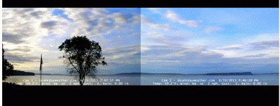
You can get a closer view by just watching the western cam. Here is is:

You can see the origin of these complex winds by looking at a few weather maps---all valid at 11 AM. An upper level map (300 hPa pressure, about 30,000 ft) shows the trough south of Washington and strong southeasterly flow over Washington. That is why the upper clouds were streaming towards the NW.


The observed surface winds show weak easterlies near the surface over the cam location. The easterlies were probably due to weak troughing to the northeast of the Olympic Mts.

The vertical shear of the wind was quite apparent still at sunset (and very beautiful as well)
Large directional and wind speed shear in the vertical is not unusual around our region, and as noted above, our terrain is a major contributor.
One final thing...large vertical wind shear can produce turbulence for those flying through it. There was major vertical wind shear (mainly in speed) between roughly 15,000 and 25,000 ft over our region today (the southeasterly winds strengthened rapidly with height) and this led to many reports of light to moderate turbulence. Here is an example pilot report (pirep):
SEA UA /OV SEA104035/TM 1726/FL250/TP B737/TB LGT OCNL MOD CHOP 250-210/RM -ZSE(translation. Turbulence light with occasional moderate chop between 21,000 and 25,000 ft)


0 nhận xét:
Đăng nhận xét