
And we broke or tied some amazing records this month: be prepared to be impressed. I had to wait until this evening to be sure about several of these records, as a band of convective showers moved northward across the region during the afternoon and early evening hours. But now the story is clear.
Perhaps the most extraordinary occurrence was the aridity of the northern Washington coast. Quillayute (near Forks) tied the driest month on record set 124 years ago in 1889 (.01 inch). The precipitation record I am referring to actually combines two stations because of a move. From 1883-1966, the station was at Tatoosh Island and from 1966 on a Quillayute. This is a very big record to tie. No one alive today has experienced such dry conditions on the coast.
What about Seattle? The airport only had a trace of rain, the driest since 1960. There are plenty more of these, but you get the point.
To get some perspective on this, here is a map (from the Western Region Climate Center) showing the percentage of normal precipitation for July 1-30, 2013. The Northwest was VERY dry, with the coastal region experienced 2% or less of normal.

But what about July temperature? How many ways can you say perfection? Let's start with Seattle-Tacoma Airport. In the figure below the red line is the average high and blue line is the average low. Only about a handful of days were below normal and only two days failed to reach 70F. No days in the 90s.

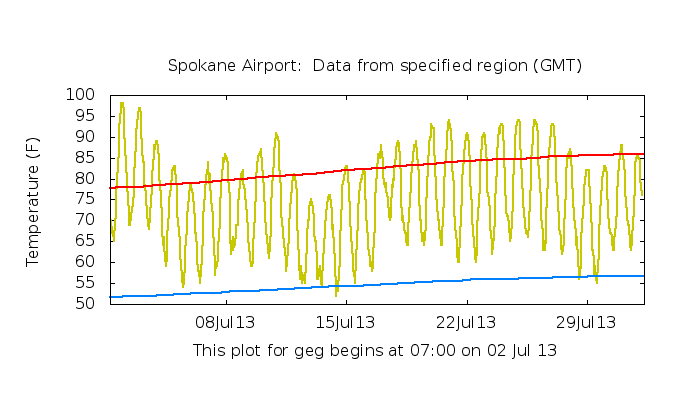
Pasco and Spokane? Same story, but add 10-15F. Warmer than normal with very little cool weather (see graphics). Obviously, the drought and warmth east of the Cascades has a down side, with a substantial fire threat (essentially we had mid to late August ground/fuel moisture in late July).


I have looked through the Sea-Tac records of the past few decades and could find no July as comfortable as July 2013. This is surely the best July on record for most of you.


Enjoy. You will be telling your grandchildren about this July one day.


0 nhận xét:
Đăng nhận xét