
In comparison, the Pacific Northwest is a thunderstorm and severe thunderstorm desert. Below is a map showing the number of days with thunderstorms a year. Zero to 10 days (gray color) over Washington and coastal portions of Oregon and California. Kind of sad.


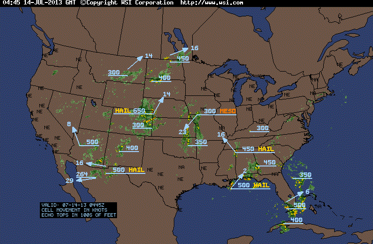
Northwest thunderstorms are rather pathetic creatures, with low tops. It is so bad that Northwest meteorologists get excited if one gets to 20 thousand feet. To illustrate, here is a graphic showing the current thunderstorm tops around the U.S. (10 PM PDT Saturday). Nothing going on in our neck of the woods, but tops of 50,000 and 65,000 ft over the eastern two-thirds of the nation. (650 means 65,000 ft, 300 means 30,000 ft, etc.)
Our thunderstorms are infamous for sparse lightning (one boom wonders) and only rarely possess rotation. No storm chaser companies will ever set foot in our region.
Who or what can we blame for our thunderstorm weakness?
The answer is clear: the Pacific Ocean.
Thunderstorms thrive when the environment has a large decline of temperature with height (called the lapse rate in the weather biz) and the atmosphere has a lot of moisture.
Let's take lapse rate...ours are generally not that large. First, the Pacific Ocean sea surface is quite cool (about 50F in summer) and our air is generally coming off the ocean. So we start with the lower part of the atmosphere being cool. Not good. Then we generally have high pressure over the eastern Pacific in summer (the East Pacific High) and that is associated with descending air and warm temperatures in the middle portion of the troposphere (the lowest layer of the atmosphere, from roughly 0 to 30,000 ft). With cool temperatures near the surface and warm air aloft, it is hard to get a large decrease of temperature with height over our region during the summer. Strike one for thunderstorms.
Thunderstorms are also helped by having lots of moisture in the lower atmosphere. Why? When air becomes saturated and rises, heat is released (called latent heat) and this heating makes the air more buoyant in the thunderstorms. Now the amount of moisture that air can contain depends on temperature (warmer air holds more water vapor). Well, the Pacific and the air next to it are quite cool; thus the air can't pick up much moisture! Strike two for thunderstorms.
Really big, severe thunderstorms also need large vertical wind shear (large change in wind speed or direction with height). Wind shear typically is fairly modest around here during the summer, since high pressure dominates our weather. Strike three for thunderstorms.
Thus, for a number of reasons, our thunderstorms are the 98 lb weaklings of the weather world. But the eastern U.S. folks should not get too smug, during the winter our weather bulks up!

COSMIC-2
In a recent blog I talked about the importance of GPS weather satellite like COSMIC and the fact that NOAA and Congress appears to turning down the chance to work with Taiwan to launch the next generation of these satellites, with Taiwan paying for half the bill. Really bad move--we critically need the data. You can ask your representatives in Congress to support COSMIC-2 by going to this web site and providing your name and email. Thank you...its important.


0 nhận xét:
Đăng nhận xét